Pettenbach


Pettenbach borders on the Almfluss river to the west and the Aiterbach river to the east and has an overall north-south extension of 14 km.
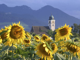
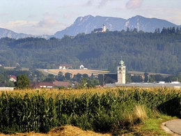
Set at the entrance to the Alm Valley, sprawling across the western parts of the Traun-Enns region, the snug town of Pettenbach marks the transition between the mountains and the foreland basin. The earliest traces of settlement (excavations of rock gardens along the Alm river and the Aiter creek) are said to date back to the Stone Ages.
There is historic proof of Illyrian and Celtic influences on the area. Pettenbach once marked the crossroads of the ancient salt and iron roads, and has therefore been attracting settlers since pre-historic times.
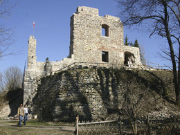
Today, sights such as the "Grüne Erde-Welt (Green Earth World), the "Seisenburg" ruins, the "Bartlhaus" writing and printing museum, the Peace Cross on the peak of the "Oberkaibling" mountain, the pilgrimage churches of "Heiligenleiten" and "Magdalenaberg" attract guests.
Numerous hiking trails, from the Almuferweg "Genuss am Almfluss " (enjoyment along the Alm river) to mountain hikes on the "Pernecker Kogel" mountain. Also the two state cycle paths R 11 Almtalweg and R 13 Traunviertel cycle path cross in Pettenbach and offer wonderful connections to the southern and northern Almtal as well as towards the Trauntal and Kremstal, this bike tour leaves The best way to explore is on the Traunviertel tour, which leads on these paths.
5.111Inhabitants
55 km²Area
486 - 1080 m ASLElevation
47.96, 14.02GPS coordinates
How to get to Pettenbach in the Almtal:
We recommend travelling by public transport!
by train: from Wels railway station, take the Almtalbahn (line 153) in the direction of Grünau im Almtal to the Pettenbach stop;
further stops in the local area: Wilfling, Diensthubersiedlung, Steinbachbrücke
Numerous connections from Wels railway station to the main trains on the Westbahn line (line 101) or to Passau (D).
By bus:
OÖVV bus route 456 Kirchdorf/Kr. - Steinbach am Ziehberg - Pettenbach
OÖVV bus route 480 Kirchdorf/Kr. (- Schlierbach) - Pettenbach - Scharnstein
OÖVV bus route 481 Kirchdorf/Kr. - Inzersdorf - Pettenbach - Lederau - Eggenberg - Vorchdorf
by bike:
Cycle path R11 Almtalradweg from Wels into the Almtal valley to the Almsee lake, the cycle path leads through Pettenbach, branching off towards the centre is possible.
Traunviertel tour - stage 2 from Schlierbach to Gmunden - the cycle route also leads through Pettenbach in the direction of Scharnstein
by car:
Motorway A1 Westautobahn Exit 207 Exit Vorchdorf at the roundabout - direction Pettenbach, approx. 12 km
Motorway A9 Pyhrnautobahn Exit 5 Ried im Traunkreis - direction Voitsdorf - Pettenbach, approx. 10 km
Parking: Please only use the designated car parks and show consideration for private property! Thank you for your fairness!
by plane:
Blue Danube Airport Linz/Hörsching 45 km
W.A. Mozart Airport Salzburg 100 km
Vienna International Airport Vienna/Schwechat 240 km
Franz-Josef Strauss Airport Munich 270 km
Mobility on site with the Salzkammergut Shuttle Service
Please call +43 (0) 50 - 422 422 at least 1 hour before the start of the journey! We are available for you by telephone daily from 6:00 to 19:00.
Outside our opening hours, you are welcome to book your journey in advance via the otaxi app and pay conveniently!
Download the app now!
Route 70
Scharnstein town centre - Grüne Erde Welt - Steinbach a. Z. - Pettenbach - Fischböckau - Vorchdorf railway station
Daily from 07:00 to 20:00 every hour, also on Sundays and public holidays.
Top highlights
")
Contact
Kirchenplatz 3
4643 Pettenbach
Phone +43 43 8155 - 0
Fax machine +43 7586 8155 - 25
E-Mail almtal@traunsee-almtal.at
Web www.pettenbach.at