

KURRENT - Art your Village - project of the European Capital of Culture Bad Ischl and the Salzkammergut 2024


- pets allowed
- All weather
- Suitable for families
- Suitable for kids (all ages)
- culturally interesting
- Possible accommodation
Interactive elevation profile
Create PDF
Tour-Details
Paths covering:
KURRENT
Art Your Village - the outside view
The exploratory artistic view from the outside is directed towards local communities, traditions and rituals, history and stories, cultural activities, perhaps also conflicts and points of contention.
Elena Mazzi
KURRENT
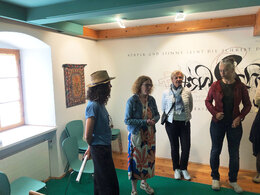
Public intervention with Joseph Micelli (Il Letterista)
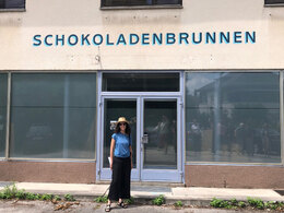
Kurrent is a project by Italian artist Elena Mazzi. Invited to work in the local environment of Pettenbach, Mazzi decided to start from the cultural heritage marked by the presence of the "Bartlhaus" museum, created by the graphic artist Leopold Feichtinger in the 1990s. His artistic work includes a large number of ex-libris and calligraphic sheets, as well as around 400 sgraffiti. The museum came into being thanks to his personal commitment, when he decided to place his own property at the disposal of the community and to set up an association to give the museum a legal basis. The museum was the result of a collective local effort by the entire community to help the artist complete the building.
Based on this context and the realisation that many activities had ceased in recent years, Mazzi invited residents and young people to discuss and rethink public space. People experienced imaginative places, formulated wishes and ideas about what they would like to see in their community.
In dialogue with the legacy left by Feichtinger on the walls, Elena Mazzi commissioned Joseph Miceli (Il Letterista) to create hand-painted signs based on the interviews and workshops, which will turn Pettenbach into a place of wishes and utopias - a place with a positive future!
The project will be accompanied by a publication to be published in 2025. This will be produced in collaboration with Maryaam Fanni, a doctoral candidate in design at the HDK Academy of Design and Crafts, who is working on signage systems as a technology for controlling the aesthetic order of the city.
European Capital of Culture Bad Ischl and the Salzkammergut 2024 in Pettenbach:
As part of the European Capital of Culture Bad Ischl and Salzkammergut 2024, visit this Art Your Village - der fremde Blick tour through the market town of Pettenbach in Almtal!
Further information can be found on the website of the Capital of Culture Bad Ischl - Salzkammergut 2024.
Starting and ending point is the Bartlhaus Writing Museum
Easy walk on roads and pavements.
How to get to Pettenbach in the Traunsee-Almtal region
We recommend travelling by public transport!
by train: from Wels station take the Almtalbahn (line 153) in the direction of Grünau im Almtal to Pettenbach station, numerous connections from Wels station to the main trains on the Westbahn line (line 101)
by bus: OÖVV bus route 456 Kirchdorf/Kr. - Steinbach am Ziehberg - Pettenbach or OÖVV bus route 481 Kirchdorf/Kr. - Inzersdorf - Pettenbach - Lederau - Eggenberg - Vorchdorf, bus stop Pettenbach OÖ Bahnhof
The Bartlhaus is only 3 minutes away from the railway station.
With the Salzkammergut Shuttle Service Route 70 from Scharnstein or Vorchdorf, please call the taxi centre at least 1 hour in advance on 050-422 422 or order on the otaxi app.
Bike & Hike, travelling by bike:
Coming from Wels or Linz on the R 4 Traunradweg or R6 Römerradweg, or from Gmunden R 4 Traunradweg or from Passau via Vöcklabruck and Schwanenstadt on the R 6 Römerradweg to Lambach, via the Traunkraftwerk Lambach and to Bad Wimsbach-Neydharting in the direction of Vorchdorf Einsiedling. Continue via the cycle connection briefly onto the R 13 Traunviertlerradweg to the R 11 Almtalradweg to Pettenbach. The town centre is not directly on the cycle path.
There is also a cycle connection on the Traunviertel Tour from Gmunden via St. Konrad and Scharnstein to Pettenbach.
By car:
West motorway A1: Vienna - Voralpenkreuz-A9 &
Inntal motorway A8 Passau - Wels - Voralpenkreuz A9 - - exit Ried/Tr. - Voitsdorf - Pettenbach
Western motorway A1: Munich - Salzburg - exit Vorchdorf - Pettenbach
Car park at Pettenbach railway station
Please only use the designated car parks and show consideration for private property! Thank you for your fairness!
- Parking space: 20
The path is free to walk on!
- All weather
- Suitable for groups
- Suitable for schools
- Suitable for kids (all ages)
- Pets allowed
- Suitable for teenagers
- Suitable for seniors
- Suitable for single travelers
- Suitable for friends
- Suitable for couples
- Suitable for children
- Spring
- Summer
- Autumn
Please get in touch for more information.
4643 Pettenbach
Phone +43 7616 8268
E-Mail almtal@traunsee-almtal.at
Web www.salzkammergut-2024.at/projekte/…
Web traunsee-almtal.salzkammergut.at/
https://traunsee-almtal.salzkammergut.at/
Vis-à-vis users
1. The tours presented for hiking, walking, biking and road biking, mountain biking, motorbiking, horseback riding, climbing, cross-country skiing, and going on skiing and snowshoe tours etc. are to be considered non-paid tour recommendations and only serve as non-binding information. We have no intention of concluding a contract with the users of this website. The utilisation of the data does not lead to the establishment of a contract with us.
The data may only be used for private use; any commercial use is prohibited. In particular, it is not permissible to offer the data on commercially run websites, file-sharing platforms etc. or to use it to develop commercial products. Downloading data does not imply that users are granted rights to the data concerned.
The tour recommendations posted were created with utmost care; nevertheless, we assume no liability for the correctness and completeness of the information.
We point out that neither the tour recommendations included on this website nor the associated data and information were posted by us, but rather by third parties (Art. 16 Austrian E-Commerce Act). We have no influence on whether the details provided (e.g. distance, level of difficulty, change in altitude, description etc.) are authentic, correct and complete. We do not review these third-party contents. For this reason, we assume no liability for the authenticity, correctness and completeness of the information.
Construction-related measures or other influences (e.g. landslides and similar occurrences) can lead to temporary or permanent changes in a route (e.g. loss of a bridge and similar occurrences). Such occurrences can lead to part of the route or the entire route becoming impassable.
The use of the data as well as undertaking (riding, walking, taking etc.) the recommended tours or using the network of paths occurs at users’ own risk and on their authority. In particular, users themselves are responsible for the choice of route, outdoor orientation, adherence to traffic rules, supplies and equipment for tours listed in Point 1 (e.g. bicycle etc.), wearing a helmet, estimating their own fitness, recognising dangers and maintaining an appropriate velocity. We exclude ourselves from any liability whatsoever for damages, in particular accidents, that occur whilst taking part in the recommended tours.
2.Some of the tours lead over roads with normal traffic conditions. Please observe that there is an increased risk which can be avoided by means of appropriate attention and proper estimation and implementation of one’s own abilities. For this reason, please travel a route that is unfamiliar to you slowly and with special care. Pay constant attention to potential dangers and always observe traffic. Do not leave the routes featured in descriptions.
The potential use of private roads, in particular forestry roads and agricultural transport roads, can be subject to legal restrictions, which must be observed and adhered to.
The normal traffic rules apply. Each user (e.g. biker, motorbiker) is responsible for adhering to these rules and maintaining his/her bike/vehicle and its equipment (lights, brakes etc.) in good working order. Each user is also responsible for ensuring that he/she rides at a velocity that is appropriate for the conditions and his/her skill level and for maintaining sufficient distance to the rider in front. We explicitly recommend adjusting velocity to correspond to the respective field of vision, wearing a helmet, using reflective clothing (or similar) and employing bicycle lights in line with regulations.
3.Each tour requires good physical fitness as well as detailed planning. We explicitly recommend only taking the tours in the case of optimal healthiness.
We recommend that you conclude an accident and liability insurance policy. Use an onboard computer that displays the respective kilometres travelled per day and is calibrated for the front wheel.
4.Special for mountain bikers – Fair-play rules:
Mountain biking is one of the most wonderful outdoor leisure-time activities. Whilst biking or on a mountain biking tour, mountains and lakes, meadows and cabins are re-discovered in new ways. A couple of rules for fair play in the forest help to avoid conflicts whilst mountain biking.
a.Pedestrians have the right of way: We are accommodating and friendly to pedestrians and hikers. Upon encountering these fellow travellers, we alert them by using the bicycle bell and slowly overtake them. We avoid paths with heavy pedestrian traffic altogether. Take nature into account: We do not leave refuse behind.
b.The braking distance should be half of the total distance visible: We ride at a controlled pace, are ready to brake and maintain a braking distance half as long as the total distance visible, especially in curves, because we always have to count on obstacles on the path. Damage to the path, stones, branches, wood piles, grazing livestock, cattle grids, barriers, tractor-type forestry machines and authorised vehicles pose dangers that we need to be ready for.
c.Don’t drink and drive!: Do not drink alcohol when mountain biking. Take care at stop-off points (dealing with bike racks, dirty shoes or clothing).
It is obligatory to provide first aid!
d.Marked routes, closed paths and blockades: Keep to the marked routes, observe the blockades and accept that these roads are primarily for agricultural and forestry use!
Blockades can often not be avoided and are in your own interest. Biking beyond the intended path and outside of opening times is punishable and turns us into illegal bikers.
e.We are guests in the forest and behave accordingly, including vis-à-vis forestry and hunting staff. Whilst mountain biking, mobile telephones and music players are forbidden! Biking requires your full attention.
f.Avoid unnecessary noise. Out of consideration to the animals living in the wild, we only bike during full daylight. As a principle, we always wear our helmet (even when riding uphill)! Don’t forget emergency supplies: We always have a repair set and bandages along.
g.Don’t overestimate your skills: We should not overdo it when it comes to biking technique and physical fitness. Take the level of difficulty posed by the route into consideration and make a precise estimate of your experience and skills as a biker (braking, bell, lights)!
h.Close gates: We approach grazing livestock at a walking pace and close every gate behind us. We should avoid causing escape and panic reactions in the animals. Nothing stands in the way of the fun and athletic challenge in the mountains and forests!
i.Traffic rules: The general traffic rules (StVO) apply for all the mountain biking routes and we adhere to them. Our bike therefore needs to be in perfect technical condition and equipped in line with the traffic rules, including brakes, a bell and lights. We inspect and service our mountain bikes regularly anyway.
5.We assume no liability for the contents of external websites; in particular, we assume no liability for their statements and contents. Moreover, we have no influence on the design or contents of the websites to which hyperlinks on traunsee.salzkammergut.at lead or from which hyperlinks lead to traunsee.salzkammergut.at. There is no on-going review of websites to which hyperlinks on traunsee.salzkammergut.at lead or from which hyperlinks lead to traunsee.salzkammergut.at. We do not appropriate the contents of websites to which hyperlinks on traunsee.salzkammergut.at lead or from which hyperlinks lead to traunsee.salzkammergut.at.
Vis-à-vis bloggers
PLEASE OBSERVE:
1. Each of your tour recommendations for hiking, walking, biking and road biking, mountain biking, motorbiking, horseback riding, climbing, cross-country skiing, and going on skiing and snowshoe tours etc., along with other details and information, is free of charge. In particular regarding the correctness of the information, we assume no liability, nor do we assume any liability whatsoever for the consequences of the use of your tour recommendation by a third party (in particular by a user of this website). We do not review the tour recommendations you post, including other details and information, at any time.
We have no intention of concluding a contract with persons who post tour recommendations and/or other details and information on this website. Posting data (information) does not imply that a contract has been concluded.
By recommending a tour, we assume special responsibility vis-à-vis other athletes. Please take this responsibility seriously and describe your tour recommendation with utmost care and to the best of your knowledge and belief.
2.Your tour recommendations must therefore clearly and unambiguously include at least the following criteria and provide a sufficiently detailed description:
• Starting point
• Detailed route description
• Distance/Overall distance
• Level of difficulty
• Dangerous spots
• Average duration of trip
• Change in altitude
• Finishing point.
If possible, please provide the change in altitude.
3.When you post a tour recommendation, you give us the order to save your tour recommendation and/or the details you provide on our website and to make it/them accessible to third parties, in particular to users of this website, in the long term. We reserve the right to block or delete tour recommendations and/or other details and/or information that you post, either partially or entirely, at any time without providing a justification. Should this occur, it grants you no rights whatsoever.
Thank you for your efforts!
4. We are not responsible for the contents of external websites; in particular, we do not assume any liability for their statements or contents. Furthermore, we do not influence the design or contents of websites that can be accessed from traunsee.salzkammergut.at via hyperlinks or that use hyperlinks to refer to traunsee.salzkammergut.at. The websites that can be accessed from traunsee.salzkammergut.at via hyperlinks or that use hyperlinks to refer to traunsee.salzkammergut.at are not regularly monitored. Furthermore, we do not assume any claims to the websites that can be accessed from traunsee.salzkammergut.at via hyperlinks or that use hyperlinks to refer to traunsee.salzkammergut.at.
Interactive elevation profile
Create PDF
Tour-Details
Paths covering: